Aerial imaging is not new, and scientists have been using data gathered from manned flights for decades. In recent decades, Earth-oriented satellites have become the dominant method of collating ...
In October 2011, the Greek container ship MV Rena ran aground on Ōtāiti, also known as the Astrolabe Reef, off the coast of Tauranga. The oil spill resulted in the New Zealand’s worst maritime ...
On 5 October 2011, Maritime New Zealand was called to respond to an ‘incident’ in the early hours of the morning. The 236 m cargo vessel Rena had struck the Astrolabe Reef about 12 nautical miles ...
In this activity, students select items to include in a home disaster kit in case of emergency and calculate how much food and water they will need to include in a disaster kit for their family ...
In this activity, students work in small groups to select a 6-member disaster response team from a set of 12 biography cards. By the end of this activity, students should be able to: better ...
This comprehensive worldwide online citizen science (OCS) project collates bird species, numbers, locations and times of sightings into a large database. You can create a class as a user and, by ...
Globe at Night is an international citizen science campaign to raise public awareness of the impact of light pollution by inviting citizen scientists to measure and submit their night sky ...
Loss of the Night is an international citizen science project aiming to quantify the illumination of the night sky caused by artificial light. By monitoring how bright the night sky is over time ...
About 14,000 earthquakes are recorded in and around New Zealand every year. Canterbury’s 7.1 and Kaikōura's 7.8 magnitude earthquakes and subsequent aftershocks show the constant threat ...
With 75% of New Zealanders living within 10 km of the coast, many students will be familiar with estuaries. In scientific terms, estuaries are the interface between the land and the sea – the ...
In this recorded professional learning session, Greta Dromgool and Ben Moorhouse from the Department of Conservation unpack conservation education and: introduce some exciting DOC resources aimed ...
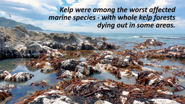
A Sustainable Seas National Science Challenge project led by Dr Leigh Tait monitored kelp recovery after the 2016 Kaikōura earthquake. NOTE: This video has no voice over or dialogue, only ...
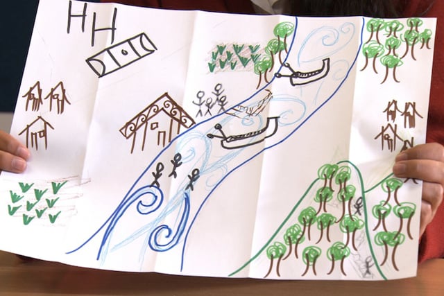
An important aspect of the government’s Long-Term Environmental Recovery Plan after the Rena disaster was to assess the impacts of the pollution and clean-up from a cultural perspective. A ...
The Ake Ake model is a pictorial mapping of someone’s perspective. Researcher Lorraine Dixon uses the model to encourage iwi to share their views including values and possible issues around ...
Dr Candida Savage explains the clues she collects in estuaries and fiords, to understand how changes in land use affect these environments.
Learn how farms can keep waterways healthy for those downstream and for our precious native freshwater fish, all while benefiting farm health and the farming operation’s bottom line.
Tirohia ngā rautaki e ora tonu ai ngā arawai mō ērā kei te taha whakararo o te wai me ngā ika taketake, waihoki ka whaihua hoki ngā pāmu, e kore ai hoki e heke iho ngā putanga.