Artificial sensors and probes enable us to overcome the limitations of our human senses and extend them in novel and useful ways, using the scientific concepts of electricity and waves. Find out ...
An inquiry approach is a method often used in science education. The question bank provides an initial list of questions about monitoring our environment using artificial sensors and places where ...
Using super sense technology, changes in the Earth’s structure can be measured without having to actually be there: Motion sensors called seismographs record tremors or small earthquakes that ...
The series of activities described below was designed to help students develop an understanding about earthquakes in New Zealand, including why we get them and how we measure them. The world of ...
In this activity, students take on the roles of seismologists, vulcanologists and geographers, using maps to look for patterns in the worldwide distribution of earthquakes, volcanoes and ...
In this activity, students use maps to plot a graph of earthquakes under New Zealand to show the shape of the North Island subduction zone and compare this to the distribution of earthquakes in ...
Large snow events in most parts of New Zealand are uncommon. However, if you are in the South Island or the central North Island, this citizen science project could be a great one for your ...
Globe at Night is an international citizen science campaign to raise public awareness of the impact of light pollution by inviting citizen scientists to measure and submit their night sky ...
Loss of the Night is an international citizen science project aiming to quantify the illumination of the night sky caused by artificial light. By monitoring how bright the night sky is over time ...
About 14,000 earthquakes are recorded in and around New Zealand every year. Canterbury’s 7.1 and Kaikōura's 7.8 magnitude earthquakes and subsequent aftershocks show the constant threat ...
This online PD session, recorded on 18 February 2015, focuses on using Science Learning Hub earthquake resources to plan an Earth and Space science unit. It models how a variety of resources can ...
Dave Corner of Auckland’s Pakuranga College developed a successful geology unit using resources from several SLH contexts. His students were engaged because they had been to or seen many of the ...
Prof Richard Haverkamp of Massey University gives an introduction to how the famous 19th century scientist Michael Faraday made an early step towards nanoscience.
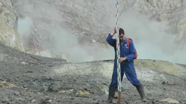
All the volcanoes in New Zealand are monitored for activity so that scientists can determine when the next eruption might be. Dr Jan Lindsay introduces us to the monitoring system and how it ...
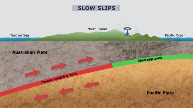
Slow slips are silent earthquakes that occur below the Earth’s surface over a large area, unlike traditional earthquakes we feel that occur in a relatively small region. Before discovering slow ...
In this interactive follow a core sample as it makes its journey from the Alpine Fault to microscopic examination.
There are many different types of volcanoes around New Zealand. This interactive map shows where the major volcanoes are, the types of volcanoes and various facts such as when they last erupted ...
This interactive groups Hub resources into key science and technology concepts.