An earthquake near Christchurch in September 2010 started a chain of events still being felt years later. It caused extensive damage to property, and aftershocks also caused injury and loss of ...
At present, it is not possible for scientists to accurately predict the time, location or strength of earthquakes, nor to tell if a swarm of small quakes are foreshocks to a larger event or just ...
Aerial imaging is not new, and scientists have been using data gathered from manned flights for decades. In recent decades, Earth-oriented satellites have become the dominant method of collating ...
In this activity, students select items to include in a home disaster kit in case of emergency and calculate how much food and water they will need to include in a disaster kit for their family ...
In this activity, students work in small groups to select a 6-member disaster response team from a set of 12 biography cards. By the end of this activity, students should be able to: better ...
In this activity, students take on the roles of seismologists and vulcanologists, using maps to look for patterns in the worldwide distribution of earthquakes and volcanoes. By the end of this ...
About 14,000 earthquakes are recorded in and around New Zealand every year. Canterbury’s 7.1 and Kaikōura's 7.8 magnitude earthquakes and subsequent aftershocks show the constant threat ...
This online PD session, recorded on 18 February 2015, focuses on using Science Learning Hub earthquake resources to plan an Earth and Space science unit. It models how a variety of resources can ...
Dave Corner of Auckland’s Pakuranga College developed a successful geology unit using resources from several SLH contexts. His students were engaged because they had been to or seen many of the ...
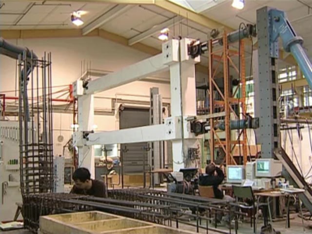
Dr Stefano Pampanin from the University of Canterbury believes seismic engineering relies on the merging of knowledge from many scientific areas, using an interdisciplinary approach and combining ...
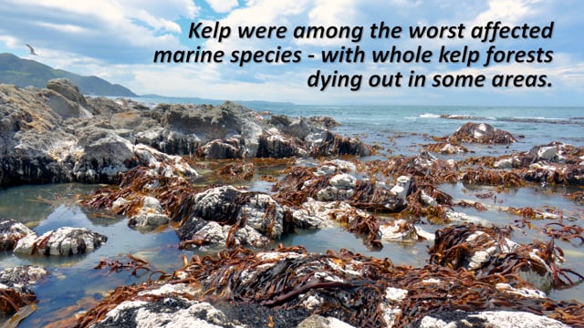
A Sustainable Seas National Science Challenge project led by Dr Leigh Tait monitored kelp recovery after the 2016 Kaikōura earthquake. NOTE: This video has no voice over or dialogue, only ...
Chris Gannon and John Meyer from Robinson Seismic explain how the Ro-Glider works. Lead rubber bearings aren’t suitable for light structures, so Robinson Seismic has developed the Ro-Glider to ...
This interactive Google map shows the sites we cored and installed observatories at during expedition #375 to the Hikurangi subduction zone. If it is not displaying, switch your browser to ...
This slideshow, from the recording Earth and Space Science scholarship introduction, provides additional support for the video tutorial.
In this interactive follow a core sample as it makes its journey from the Alpine Fault to microscopic examination.